GPS: Data is the key
04 January 2017
Satellite technology, and all its many functions that seem to invade every corner of modern life, is changing the face of the construction site, whether it is digging a hole to extreme levels of accuracy, or a fleet owner understanding where the machines are and what they are doing.
There is a long way to go yet, and it would be a brave prediction to suggest where the construction industry will be in ten years, but there are plenty of people who are willing to make a good guess at it.
Makoto Yamazawa, president and chairman of the management board at Hitachi Construction Machinery (Europe) – HCME – said, “Ultimately it will be autonomous operation – no operators – but that will take quite a few years more.”
He said that tests towards this had been going on in the mining industry for some time.
However, many people would be quick to point out that a construction site is not the same as a mine, or even a quarry, where jobs are often repetitive and almost completely predictable.
The issue of telematics is already a part of the everyday construction workplace, though. At its simplest, telematics means transmitting computerised information over long distances. For construction, it can mean a lot of things.
Yamazawa said, “One of the issues customers have is a lack of skilled operators. With the current telematics solution, we can provide very precise control of the front attachments – for example, digging at a certain angle very precisely, or even the depth or the width of the hole being automatically measured by the computer system.
“Therefore, the area of skilled operators may not be required in the future. This will help customers a lot.”
He said making the machine operate more easily was one of the areas for telematics. Another, he said, was GPS remote monitoring that would help construction companies “operate the machines in an optimised way to maintain the machines”.
Richard Clement, planning manager at Komatsu UK, said his company was moving away from “just being an OEM” to providing “smart construction” in Japan.
For Komatsu, this means connecting all jobsite information – not only construction equipment but also on people, machines and the ground – from pre-construction to completion.
The company’s KomConnect is a cloud-based software service, a platform connecting all the information. It said that by storing a massive amount of information concerning construction activities, it was able to engage in analyses, simulations and proposals.
It added that this information could be accessed by everyone concerned via the internet, anywhere, at any time.
For Europe, Clement said that the challenge was the different regulations that are in place.
“It’s about becoming a service company, understanding what the customer needs,” he said.
Machine controls
Leica Geosystems’ Danish factory in Odense is the machine controls headquarters for the company, and it has around 400 people working on machine controls – manufacturing, and research and development (R&D).
The aim is the digitisation of the whole industry, and for “intelligent construction”, it’s about connecting the whole process.
And some aspects are not that new.
Johan Arnberg, president of Leica Geosystems’ machine control division, suggested that the first things that could legitimately be classed as machine controls appeared 27 or 28 years ago.
He added, “GPS has been around for many years before it was used for machine controls.”
He said the use of machine controls was changing tasks, and therefore changing job descriptions, and this provided opportunities for younger people who were fully PC literate.
In many ways, the whole issue is about data, and the sharing of that data.
He said that it was about the complete project, “end to end, from the design stage” using data for asset management, and being more efficient.
“The total savings potential can be 35% overall,” he said.
This is where BIM (building information modelling) comes in. It is increasingly important in projects in many countries. Arnberg gave the example of Sweden where he said road projects were now designed in 3D formats.
He said that the problems, however, included the fact that there were “still separate, parallel technologies. Big companies are demanding standardisation.”
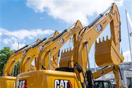
Until 2013, the market consisted, for the most part, of Leica, Topcon and Trimble. Since then, the likes of Komatsu and Caterpillar have been in the game, and Arnberg said that the next ten years could see other OEMs entering the arena.
Far from universal
Despite the wider awareness, the takeup of machine controls is far from universal, and Arnberg pointed out that some OEMs simply put in mounting kits, but he added, “At some point in the future, larger machines will get basic machine controls.”
The type of machine and the complexity of the machine controls is also a factor.
“Dump trucks, for example, just need information.”
He said the Hexagon group, of which Leica is a part, had acquired around 100 companies in the past 10 years.
“We are working towards a harmonised solution, more than we were earlier. We are working much more closely with companies in the Hexagon group, to find complete end-to-end solutions, both for hardware and software.”
On the subject of autonomous machinery, he agreed that it could work better in mining.
“In a mine, there are not many people on site. A construction site is dynamic – it changes day to day. We are happy to contribute to the development of autonomous machines within Hexagon, but it is not prioritised for us.”
Another area is augmented reality. He said this could include mock-ups of the construction site than can be viewed from a helmet, and a 360° view in machine cabs.
“Information is key,” he said, “real time data.”
He said the world would look very different in five to ten years.
“It’s moving as fast as it ever has, and will continue to do so.”
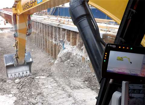
Staying in Denmark, contractor Aarsleff has been putting machine control theory into practice. On the site of a new factory in Hillerød for global healthcare company Novo Nordisk, foreman Kim Pedersen said, “It doesn’t make a bad driver good, but it makes a good driver better.”
A new section of the factory was built in record time using 3D technology both underground and on the surface, and 15 satellites have been used to make sure that the contact is continuous. Controls have been benchmarked and recalibrated every day.
Pedersen said that the latest developments have been the biggest step in working with construction machines in a long time. It was not an entirely smooth transition, though.
“With older drivers, maybe over 60 years old, it was an issue at the beginning, but they like it now.
“In Denmark, we could see the benefits. Eliminating errors is important and we can see the benefits quickly. We use to move earth several times, but now we know how much to move. Going forward, we know where everything has to be.”
Having said that, he added, “We don’t use machine controls as much as we’d like to – for example, compaction.”
He said that it was not thought that the measuring of the different types of soil was accurate enough to use in the compaction process, although it is used in some other countries.
GPS used
GPS was used extensively though on the machines at the Hillerød site, which were predominantly Caterpillar machines.
Some 90,000m3 of earth was extracted, said Pedersen. “For slopes, we used GPS to make them accurate – the right angle, etc. You still have to use your head, so it is still a very skilled job, but it saves time and money, and gives a better product for customers.”
Niels Brøndgård Jørgensen, an Aarsleff surveyor, said, “The model shows where you need people to go – for example paths and roads. Gas pipes, cables, etc, are now on the model, so it is safer. The input data is improving a lot.
“The biggest difference is you never have downtime because you can go elsewhere. Over the years it has become more efficient and more accurate”
Jørgensen added that dozer drivers were staying longer in their jobs as a result of GPS.
”They are getting job satisfaction because they are not just digging a hole.”
Pedersen and Jørgensen said that the communication between them was an important part of getting the process to work. Jørgensen added that he was working on ten to 15 projects at a time.
At the Novo Nordisk site, Aarsleff used Cat machines to carry out the land development work and the construction pit, as well as the shell structure for the large factory building. The new multi-storey building has a 5m deep basement, and the building’s foundations, construction pits and floor slabs at basement level were made of concrete cast in situ.
The time schedule for the work was tight, but Aarsleff said the project design was carried out at the same time as the execution phase, so part of the structure had to be adjusted on a continuous basis. It reported no unnecessary delays.
Rail project
At Hvidovre, a suburb of Copenhagen, Aarsleff has been working on a 2km stretch of a new rail line out of the Danish capital. Again, Caterpillar machines were used on the Copenhagen to Ringsted project, which will cover a total distance of approximately 57.7km.
The new railway line – TP4 – will connect with the existing railway system in Copenhagen. Due to be completed in 2018, new dual track, electrified railway will be Denmark’s first high speed railway and will handle passenger trains travelling at up to 250km/h.
Located in a very busy part of the Danish capital, the tight nature of the Hvidovre stretch meant that a cut-and-cover method was chosen. Started in 2014 with a two-year deadline, the project used 3D technology, and GPS was used for accurate digging with the Caterpillar excavators, including the 325F and the 329E. The GPS hardware, except for the aerial, was taken out when not needed, although 2D could still be used.
Pon Equipment is official Caterpillar dealer in the Netherlands, Norway, Sweden and Denmark, and it offers Sitech, which is a joint offering from Trimble and Caterpillar.
Bo Mikkelsen from Pon said that Sitech was regarded as a sister company, and that combining the role of machine supplier and provider of technology was significant for service plans, and repair and maintenance contracts.
He said, “Pon can advise throughout the project on how to achieve the best fuel consumption – and to be more knowledgeable about everything.”
Terex Trucks new Generation 10 machines are the first of the company’s models to come with telematics as standard. Scott Pollock from the company’s product management team, said, “The potential for telematics is huge. This is new, but we have dabbled in it in the past.”
He said there were five main areas – machine tracking, fuel consumption, condition alert (for example, a high temperature alert), machine hours and idle time.
“There’s a whole host of other things, though,” he added. “It’s almost limitless. We don’t want to baffle our customers, so we find out what they want or need. It’s about protecting the asset and its residual value.”
Hitachi has two new remote machine monitoring systems that have been developed as part of its Global e-Service online application.
Available in many languages, Owner’s Site and ConSite are available for Zaxis-3 and Zaxis-5 medium and large crawler, and wheeled excavators, as well as ZW-5 wheeled loaders.
Global e-Service allows owners to monitor their Hitachi construction machinery remotely. The machines send operational data on a daily basis via GPRS or satellite to www.globaleservice.com. This is said to allow immediate access to its “new and improved” Owner’s Site.
As each project is different, the Owner’s Site dashboard can be customised to view all the relevant data by defined machine group or job site. Comparing the ratio of operating and non-operating hours helps to boost productivity and enhance the efficiency of each machine.
Effective management
The effective management of maintenance programmes through the Owner’s Site will help to maximise the availability of Hitachi construction machinery. Running costs can also be managed more effectively by analysing the fuel consumption. Working across different job sites makes planning essential, and the location and movements of each machine are clearly displayed.
An automatic service report – ConSite – sends a monthly email summarising the information from Global e-Service for each Hitachi machine. This includes a detailed analysis of the operational data, ratios and hours.
Tom van Wijlandt, HCME’s assistant manager service development, said, “Global e-Service continues to enhance the customer experience of using and managing Hitachi construction machinery through these two unique developments.
“Owner’s Site and ConSite will provide information that they can use to maximise the efficiency, minimise downtime and improve the overall performance of their Hitachi fleets.”
In the UK, PQS Survey, a national hirer of survey and safety equipment, has selected Topcon GB & Ireland as its machine control technology partner.
The deal means PQS customers will now have access to Topcon’s full range of machine control systems, which it said featured GPS technology for faster, easier and more cost-effective earthworks.
Carl Pick, managing director of PQS, said, “We’ve seen a significant increase in the demand for equipment that offers more sophisticated ways of working. Many of our customers now want to go from design to completion using 3D models, for example.”
As part of the new deal, PQS will be offering customers the latest addition to Topcon’s machine control range, the GX-55 control box, with a 6.5in (165mm) sunlight-viewable LCD touchscreen and integrated LED light bars.
David Bennett, business manager at Topcon, said, “Machine control technology is still in the early stages of adoption, but it’s having an astounding impact on construction.”
Sokkia, part of Topcon, has introduced new field and office software solutions for its total stations, robotics and GNSS (global navigation satellite system) rover systems – GeoPro Field and GeoPro Office.
GeoPro Field provides a graphical user interface designed to collect field measurements easily for land surveying and construction activities.
Ian Stilgoe, vice president portfolio management at Topcon Positioning Group, said, “End-users needing a field tool to collect and import measurement data into design and drafting software will find GeoPro Field to be a fast and accurate method that will increase productivity with CAD functionality in the field.
“A key to GeoPro Field is its compatibility with various software workflows – data files are easily exported to third-party software.”
Sokkia GeoPro Office is described as the office-processing complement to the field software – designed to clean, process, and analyse field data into its easiest-to-use form.
Septentrio, provider GNSS receivers, has released of 5.1.0 firmware for the PolaRx5 product line of GNSS reference receivers.
It said the 5.1.0 firmware brought new features for file management, usability, security and seismic monitoring. Septentrio’s PolaRx5 product line of GNSS reference receivers includes the PolaRx5 for CORS and network operations, the PolaRx5TR for time and frequency transfer and the PolaRx5S for space weather applications.
Improvements in Precise Point Positioning (PPP) was said to have opened the door on seismic monitoring using GNSS technology.
As well as allowing precise measurement of long-term slow surface displacement, PolaRx5 now allows real-time recording of the high-frequency vibrations typically accompanying earthquakes.
Firmware 5.1.0 introduces the support for on-board PPP and dynamic response tuned for seismic applications.
Septentrio said the 5.1.0 firmware release provided greater logging efficiency to the PolaRx5 users.