Feature: Surveying technology
09 October 2014
With so much new and rapidly developing technology available in the surveying and instruments sector, navigating the options can be a challenge for contractors.
Along with the rise in the use of Building Information Modelling (BIM), sophisticated digital instruments, data loggers and the associated hardware and software are changing the way construction work is carried out on site and how companies approach construction work.
But while this may be a challenge for the industry, it is also an opportunity. With contractors facing tight deadlines, using time-saving devices for the planning and execution of projects can make a difference to timelines and budgets as well as reducing waste.
For example, just a few years ago, even the thought of using drones for commercial topographical mapping was considered something that was far more the territory of military surveillance.
But a growing number of companies have switched on to the potential for using sophisticated small drones as a quick and efficient means of surveying construction and mining sites.
Manufacturers have been far from slow in engaging with development of technology that is now widely in use amid other business sectors.
Surveying advances
As Bernd Moeller, Leica’s senior product manager explained, there have been some momentous changes to the surveying scene in recent years, yet he believed his company had worked hard to respond to customers’ demands.
This includes the introduction of its own series of products such as
its latest icon builder 60 and icon robot 60 for automated measuring and positioning tasks.
He pointed to a clear trend of younger “Nintendo generation” project managers who had engaged with latest techniques such as using computer-based tablet planning of surveying tasks and BIM computer-based monitoring of construction site surveying.
In his opinion, it was this youthful set of clients that had driven demand for greater usage of technology in building tasks, which shows no sign of slowing down.
Moeller said, “This has been a busy year for us, working with customers in order to fulfill their expectations. Our goal is to find solutions that drive efficiencies and products that work well in the field.
“Over the last 5 or 10 years there have been some big changes in terms of digital equipment being used in construction and we are working hard as a company to improve the efficiency of our products.
“There is a lot of competition in the construction industry now and contracts may be awarded to those who are using the new technology. There is so much out there such as total surveying stations robotic stations that have seen a tremendous increase in use.”
He added that the use of BIM processes in the design phase of 3D mapping of sites through computer aided design (CAD) with the company’s own own Cyclone laser scanning software module, during construction has become increasingly common for larger-scale projects.
This was especially the case, he said, given its potential to reduce physical waste on a site through accurately gauging physical requirements for a site.
While it remains a growing trend, just how challenging has it been to design software and equipment that assists the flow of work and exchange of BIM information between designers and site workers?
“Communicating information between the design stage and the site is clearly one of the biggest challenges that companies face. So we try and help in designing products that have people in their comfort zones – we are not trying to change the way people actually work, just alter their methods.
“We’ve done this by getting involved with a number of user groups and getting feedback from people in the industry.
“We have found that it is largely those working on bigger contracts that are using BIM data in the design phase and we have worked with them to find solutions that are as seamless as possible.
It’s a market that is growing – it is not there in all parts of Europe yet, though is something that is more important in the US.”
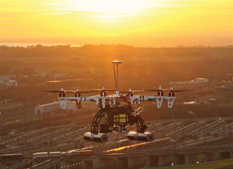
Drone Surveying
Having launched its own commercial drone series this summer (the Sirius Pro and Sirius Basic), Topcon is another company very much at the forefront of devising advanced surveying equipment.
Ian Stilgoe, Topcon’s geomatics business unit manager, said there had already been a strong response to its introduction of drone technology, which he believed would have broad application, alongside a growing array of site-based digital equipment.
He said, “Surveying has become very IT driven in recent years. The construction business has been slow to catch up with technology, but it is getting there now.
“As an industry, we are always trying to make products that are more user-friendly. This is especially the case as the surveying is now very much about making sure that everyone has access to all information relating to a job site- which is a big challenge.”
He added that the use of GPS into surveying and use of BIM data in terms of plotting construction sites digitally had been particularly influential over the past few years.
In his view, use of other advanced technology such as drones could play a significant role within the surveying sector.
He added, “Surveying has been operating drones for the past few years now and they’re being used in topographical surveys and for surveying quarries and mines.
“It’s a much faster process digitally than the tradition way of doing it – saving anything up to 40% or 50% in terms of time. It’s an area that will continue to develop.
“I think that understanding the technology that is available out there and how to adapt it for the industry is another challenge – as companies looking at anything new have to assess the risk. It takes time to do that in terms of doing the analysis on the returns that you will get.”
Trimble’s tablet app, the Trimble Contractor has been designed as a practical field tool to manage orders and construction tasks electronically. According to the company, it will have considerable benefits for those working in the field being updated with project information.
The company’s LL300N surveying laser level is aiming to be one of the most rugged products on the market.
This fully automatic, self-levelling product is designed to handle construction, concrete and site preparation applications including general elevation control, levelling forms and footers, concrete pours, excavations and basic slopes.
Featuring a glass lighthouse, the LL300N offers an IP66 environmental protection rating, which allows operation in dverse environmental conditions, including rain, according to the company. It also features easy, one-button operation for basic levelling.
“Contractors need a simple to operate, tough construction laser that is reliable and accurate day in and day out,” said Mike Bank, general manager of Trimble’s precision tools business. “The LL300N is the perfect tool for meeting those needs.”
For a wider range of applications, the optional RC601 remote control enables additional performance features including single-axis slope mode and manual slope matching capabilities.
Contractors can configure the LL300N to fit their requirements. A variety of packages are available with a choice of receiver and accessories, including a tripod and grade rod that can fit in a system case.
Cloud-based solutions
Leica’s Cyclone 9.0 point cloud solution for processing laser scan data, has potential to improve modelling of construction sites.
It has been designed to benefit both field and office via faster, and easier scan registration, plus quicker deliverable creation thanks to better 2D and 3D drafting tools and steel modelling.
Cyclone 9.0 allows users to scale easily for larger, more complex projects while ensuring high quality deliverables.
With cloud-to-cloud registration, users can accurately execute laser scanning projects without having to physically place special targets around the scene, scan them, and model them in the office.
With cloud-to-cloud software, users take advantage of overlaps among scans to register them together.
Dr. Chris Thewalt, Leica vice president for laser scanning software said, “The cloud-to-cloud registration approach has delivered significant logistical benefits onsite and time savings for many projects.
“We’ve constantly improved it, but the new automatic scan alignment and visual registration capabilities in Cyclone 9.0 represent the biggest advancement in cloud-to-cloud registration since we introduced it,”
He added, “Cyclone 9.0 lets users benefit from target-less scanning more often by performing the critical scan registration step far more efficiently in the office for many projects. As users increase the size and scope of their scanning projects, Cyclone 9.0 pays even bigger dividends. Any user who registers laser scan data will find great value in these capabilities.”
From leveling formwork and setting digital slopes outdoors, to aligning and layout work indoors, the Hilti PR 30-HVS has a wide range of functions.
It is designed to be drop-resistant from standard working height due to an internal damping system, shock absorbing case, and four shock-absorbing handles. It also has improved keypads and an integrated remote/laser receiver for maximum productivity and simplicity.
Whether measuring long distances, calculating areas and volumes, or in difficult to reach situations, the company’s PD-I and PD-E take measurements quickly and accurately, says the company.
Its pulse power technology allows for reliable measurements even under challenging conditions and have a reported accuracy of +/- 1/mm.
The PD-E laser range meter is streamlined for exterior applications. Designed for use in direct sunlight, the new E-paper screen technology helps readability even in the most challenging light conditions. Its precision optical targeting sight makes long distance measurements up to 200 m an easier prospect.
The PD-I for interior applications measures up to 100 m, allowing for overhead measurements without the use of a ladder and thus helps increase workplace safety.
The PD-I uses a standard LCD screen with brighter illumination for improved readability in darker areas.
While both tools have a small, compact design, these laser range meters are said to be rugged and durable and are equipped with an automated backlight, inclination sensor for faster indirect measurements and LED reference indicators.
Another new advance from Topcon comes in the form of its latest data controller – the FC-500. Its numerous features include a large 4.3 inch (110 mm) touchscreen display and 5 mega pixel camera with built-in LED flash.
Ray Kerwin, director of global surveying products, said, “The FC-500 works with all Topcon GPS/GNSS receivers and total stations, and meets or exceeds all field application requirements.
“Additionally, it works with the new Topcon LN-100 instrument dedicated to BIM and one-person construction layout, simplifying workflow with the seamless integration with our Magnet suite of software solutions.”
Mr Kerwin added that its sunlight readable screen made it easy to use even in bright conditions. In his view, it was an ideal piece of equipment in all conditions as it is also waterproof up to
1 m. Its camera has an LED flash and built-in 8GB flash storage allows hundreds of site photos to be stored.
The standard model has both bluetooth and wifi connectivity, while the FC-500 GEO has bluetooth, WiFi and GPS.
There is also a third model comes with the addition of a 3.5G cellular modem that allows access to the Magnet Enterprise Solutions suite.
According to the company, this has made it an especially strong field instrument for sending and receiving digital data files to the cloud.
For the GIS professional using magnet field software, the FC-500 has a geo-tagging feature that allows imprinting file information, including GPS location, directly on photos.