Liebherr launches Crane Planner 2.0
04 February 2022
The LTM 1650-8.1, LTM 1450-8.1, LTM 1300-6.2, LTM 1250-5.1 and LTM 1230-5.1 cranes are now included in the program
Liebherr’s latest lift planning software update now includes three-dimensional lift planning which can be carried out for further LTM mobile cranes from Ehingen.
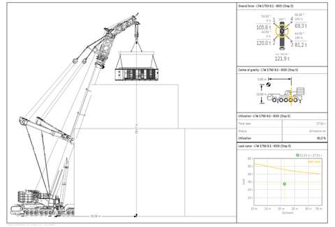 Fast generation of precise reports including a combination of all planning data (support pressures, centers of gravity, lifting capacities, etc.) for all the machines during every single step of the job.
In addition to the LTM 1750‑9.1, which was already included in the program, the LTM 1650-8.1, LTM 1450-8.1, LTM 1300-6.2, LTM 1250-5.1 and LTM 1230-5.1 are now also available for planning work. Additional telescopic mobile cranes are being added to Crane Planner 2.0 at regular intervals. The update also includes the new distance tool, which enables objects such as machines and buildings to be positioned relative to each other with centimeter precision.
The Liebherr Crane Planner 2.0 helps users to identify solutions and procedures for their lifting work in advance. This enables complicated heavy lifts with crawler cranes as well as supposedly quick and easy taxi lifts by mobile cranes to be completed safely. The tool combines an interactive 3D visualisation of the machines, the loads and surrounding objects with dimensions, a positioning tool and Google Maps, without the need for expensive CAD programs or high performance computers, the company said. The results of the planning process can be exported in the form of a report and sent to the customer.
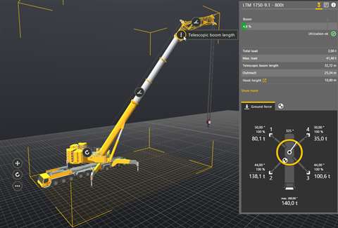 The displayed data are determined by the same calculation logic system as the live data generated by real mobile and crawler cranes. Each time the configuration, load or geometry is changed, a new calculation is carried out in real time.
The data displayed in Crane Planner 2.0 are determined using exactly the same calculation logic as the live data generated by the real mobile and crawler cranes. Key data such as ground pressures, support pressures, lifting capacities and centres of gravity are calculated simultaneously. Each time the configuration, load or geometry is changed, a new calculation is carried out.
Challenging planning tasks can be completed professionally in 2D using the ‘Free’ version. The range of functions is similar to the time-tested LICCON work planner. The ‘Pro’ version also contains detailed, interactive 3D models of the cranes, as well as a library with various 3D objects such as buildings, roads, machines or load objects. Map views from Google Maps and 3D data can be included in the display in the correct scale.
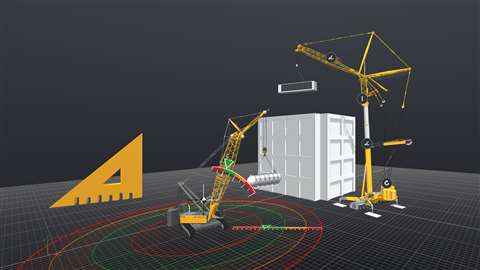 Lift planning has been taken to a whole new level thanks to Crane Planner. The combination of an attractive, three-dimensional user interface with the precise machine data of the load moment limitation system (LMB / LICCON) is unique.


